


Tapton Lock and The Chesterfield Canal
A Hidden Green Corridor in a Large Town


A Visit to Tapton Lock and The Chesterfield Canal
There isn’t much signage to tell you that a hidden gem lies here in the busy town of Chesterfield. Surrounded by busy roads, industrial buildings, car dealerships and supermarkets, a valley passed over by major roads conceals the Chesterfield Canal. Just one small brown direction sign points to an exit off the large roundabout.
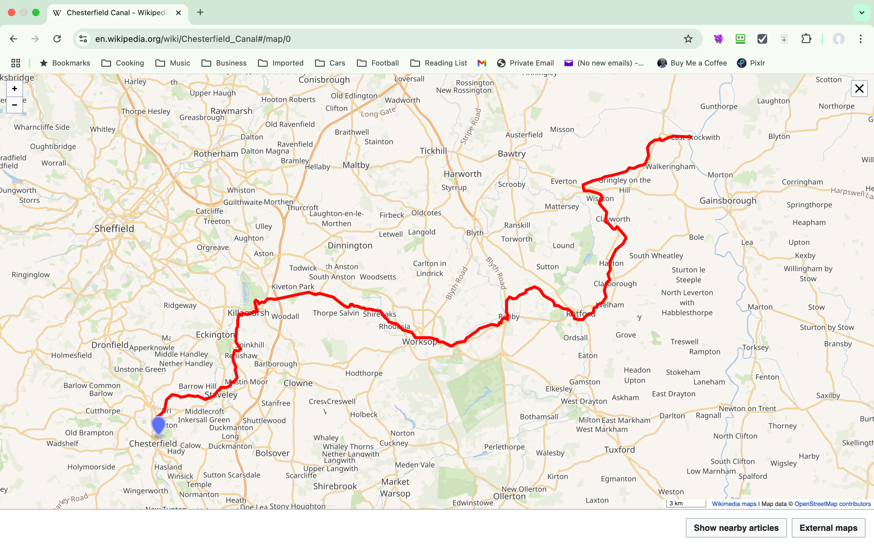
The canal was built to carry cargo to and from the Derbyshire town of Chesterfield to West Stockwith, some 46 miles east in Nottinghamshire. This created a link from Chesterfield to the River Trent, a major transport hub. The canal was the work of the famous engineer James Brindley and his assistant John Varley. Construction began in the summer of 1771. However, Brindley died in 1772, and with his death, the responsibility fell to Varley to see this project through to completion.
The Chesterfield Canal was fully opened in 1777, although it was in use as new stretches were completed. It included 59 locks plus 6 wide ones and two tunnels. The Norwood Tunnel collapsed at the start of the 20th century and was never reopened as, by that time, canal use was dwindling and would not have been economically viable.
As with most canals, the arrival of the railways brought about their demise. It was faster and cheaper to move goods by rail. English canals had a very brief golden age, with the power of the steam locomotive coming to steal that away.
By the 1960s, much of the canal was derelict and likely to disappear. Sadly, some of it has, but some people had other ideas. A group of people got together and formed a plan to restore the canal and bring it back into use for pleasure craft and others to enjoy. Although there is much left to restore, the 46-mile route is walkable.

On my walk today, I start from Tapton Lock, where the Tapton Lock Visitor Centre is located. This is operated by Derbyshire County Council and is open on Monday and Tuesday and occasional weekends. Here, you can obtain a snack or drink and even borrow a mobility scooter should you require one to enjoy a trip along the towpath. See the website for details.
The Chesterfield Canal Trust operates boat trips from here on the appropriately named John Varley ll. (See the photo at the top of the page)
46 miles is a long way, so I concentrate my efforts on the one-mile walk towards Chesterfield’s centre. Apart from the traffic noise near Tapton Lock, yes there is a lock, to allow for the drop in level on the next part of the journey east, you would not know that the area is so built up with industrial and commercial property.

Heading west, to my right, is the River Rother, which flows eastward alongside the canal. This river gives its name to the Yorkshire town of Rotherham. Walking further away from the visitor centre and having passed under. a road bridge, it becomes much quieter. To my left is a high bank upon one section are some apartments with a view of the canal, no doubt pushing their value up. For most of this walk, trees line both sides, making it secluded, and the wide towpath has enough room for walkers and cyclists to comfortably share.

There are small jetties for anglers, subject to having a fishing licence, to enjoy the pleasure of fishing in the canal and watching the passing of a flotilla of ducks.
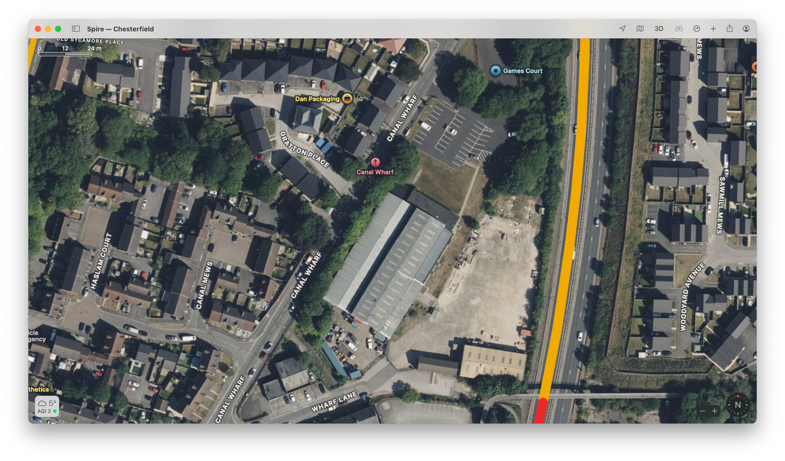
I am now approaching the furthest western point of the canal, where it meets the River Rother. The canal once went a little further to a large wharf until the railway came and dissected it. Chesterfield still has two roads indicating where Chesterfield Wharf once existed: Wharf Lane and Canal Wharf. A new wharf was opened, but, by then, trade was beginning to slump. The railway arrived in Chesterfield in 1840.
Although, a cold day, the late Autumn sunshine was pleasant, and the air was still. In a few hours, Britain is about to be struck by Storm Darragh so this was an ideal time to enjoy this walk. It really is amazing how tranquil this area is, a real green corridor in an urban landscape. For those walking east, you are quickly out into the open countryside passing through towns and villages along the way. I have added a map for you to see the route of the Chesterfield Canal.
This has been a lovely walk and a perfect morning to make a video which is now on YouTube so if you would like to watch please click here.
By the way - I have started a journey moving away from digital tools as much as possible, and I am sharing that journey at Roland’s Notebook, another Substack. Please do join me!
I hope you have enjoyed this account. If you wish to leave a comment, please do, and if you’re not a subscriber, please click the button now.